

You can find on this page the Thailand geographical map to print and to download in PDF. The Thailand geographic map presents the topography, elevation, rivers, mountains, climate and physical features of Thailand in South-Eastern Asia.
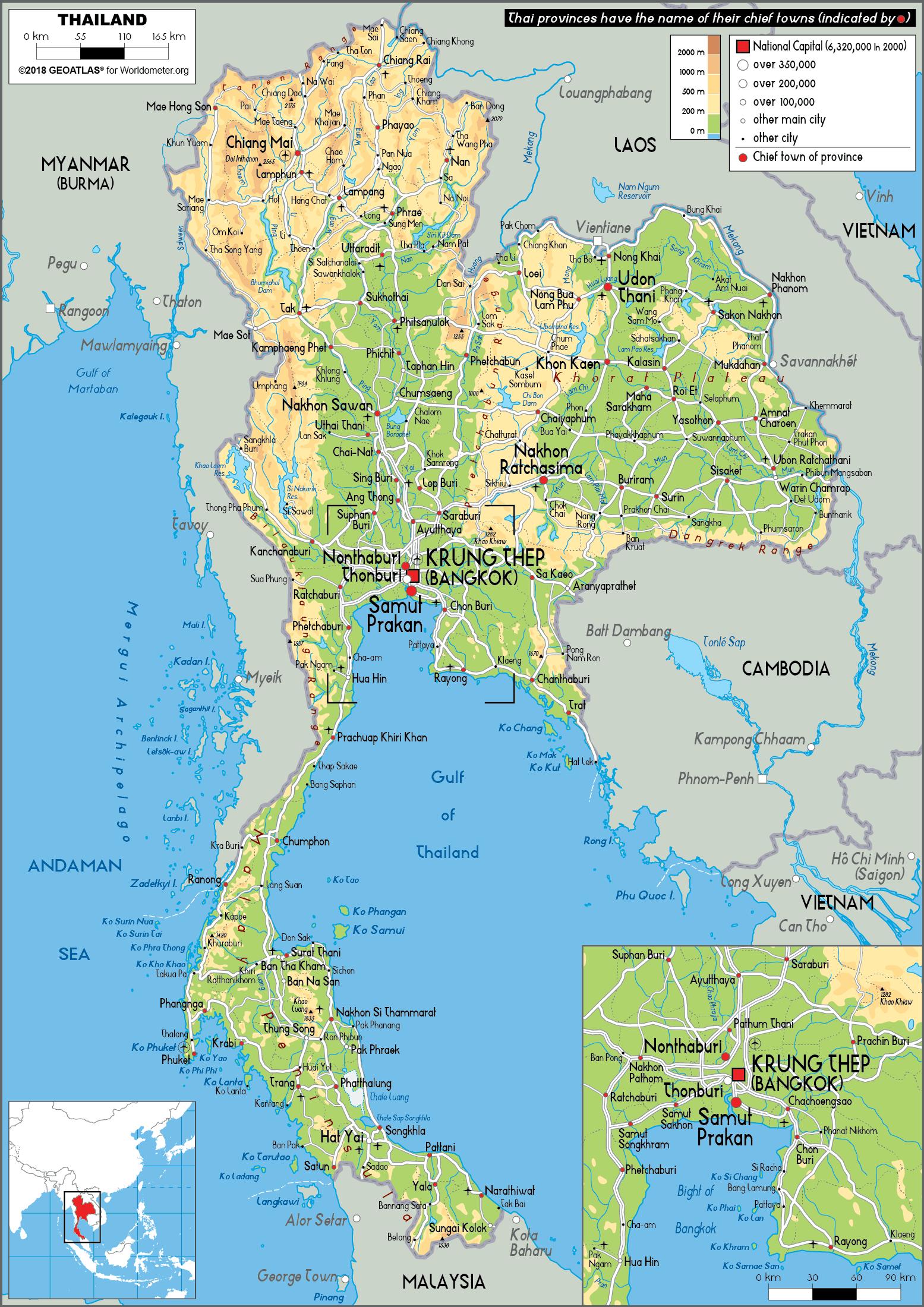
The Thailand physical map shows landform and geography of Thailand. This geographical map of Thailand will allow you to discover physical features of Thailand in South-Eastern Asia. The Thailand physical map is downloadable in PDF, printable and free.
Thailand, which has about the same physical land area as Spain or France, consists of two broad geographic areas: a larger main section in the north and a smaller peninsular extension in the south. The main body of the country is surrounded by Myanmar (Burma) to the west, Laos to the north and east, Cambodia to the southeast, and the Gulf of Thailand to the south as you can see in Thailand physical map. Peninsular Thailand stretches southward from the southwestern corner of the country along the eastern edge of the Malay Peninsula; Myanmar extends along the western portion of the peninsula as far as the Isthmus of Kra, after which Thailand occupies the entire peninsula until reaching its southern border with Malaysia at roughly latitude 6° N.
The fertile floodplain and tropical monsoon climate in Thailand, ideally suited to wet-rice (tham na) cultivation, attracted settlers to this central area over to the marginal uplands and the highlands of the northern region or the Khorat Plateau to the northeast as its shown in Thailand physical map. By the 12th century AD, a number of loosely connected rice-growing and trading states flourished in the upper Chao Phraya Valley. They broke free from domination of the Khmer Empire, but from the middle of the 14th century gradually came under the control of the Ayutthaya kingdom at the southern extremity of the floodplain. Successive capitals, built at various points along the river, became centers of great Thai kingdoms based on rice cultivation and foreign commerce. Unlike the neighboring Khmer and Burmese, the Thai continued to look outward across the Gulf of Thailand and the Andaman Sea toward foreign ports of trade.
Thailand physical landscapes vary from low mountains to fertile alluvial plains dotted with rice paddies to sandy beaches set amid the equatorial latitudes of the Asian monsoons as its mentioned in Thailand physical map. The country is divided into five distinct physiographic regions: the folded mountains in the north and west, the Khorat Plateau in the northeast, the Chao Phraya River basin in the centre, the maritime corner of the central region in the southeast, and the long, slender peninsular portion in the southwest.

Thailand topographic map shows the physical features of Thailand. This topographical map of Thailand will allow you to discover landforms and geographical of Thailand in South-Eastern Asia. The Thailand topographic map is downloadable in PDF, printable and free.
The most conspicuous features of Thailand terrain are high mountains, a central plain, and an upland plateau as you can see in Thailand topographic map. Mountains cover much of northern Thailand and extend along the Myanmar border down through the Kra Isthmus and the Malay Peninsula. The central plain is a lowland area drained by the Chao Phraya River and its tributaries, the country principal river system, which feeds into the delta at the head of the Bay of Bangkok. The Chao Phraya system drains about one-third of the nation territory. In the northeastern part of the country the Khorat Plateau, a region of gently rolling low hills and shallow lakes, drains into the Mekong through the Mun River. The Mekong system empties into the South China Sea and includes a series of canals and dams.
Thailand is divided into four natural regions as its shown in Thailand topographic map: The North, the Central Plain, or Chao Phraya River Basin, the Northeast, or the Korat Plateau, the South, or Southern Peninsula. The North is a mountainous region comprising natural forests, ridges and deep, narrow, alluvial valleys. The major city in the region is Chiang Mai. Central Thailand the basin of the Chao Phraya River, is a lush, fertile valley. It is the richest and most extensive rice-producing area in the country and has often been called the "Rice Bowl of Asia." Bangkok, the capital of Thailand, is located in this region. It is also the country largest city. The Northeast region is arid, characterized by rolling surfaces and undulating hills. Harsh climatic conditions often result in this region being subjected to floods and droughts. The Southern region ranges from hilly to mountainous, with thick virgin forests and rich deposits of minerals and ores. The region is the center for production of rubber and cultivation of other tropical crops.
The south coast of Thailand faces the Gulf of Thailand, while the Isthmus of Kra is bordered on the west by the Andaman Sea and on the east by the Gulf of Thailand. Thailand also has coastal islands in the Andaman Sea and the Gulf of Thailand. The largest, with provincial status, is Phuket, off the west coast; on the gulf side, the largest islands are Samui and Pangan as its mentioned in Thailand topographic map. The coastline is 3,219 kilometers long: 750 kilometers on the Andaman Sea and 2,469 kilometers on the Gulf of Thailand. The Andaman Sea on the east side of Thailand and Myanmar connects to the Indian Ocean. The Gulf of Thailand south of Bangkok connects with the Pacific Ocean.
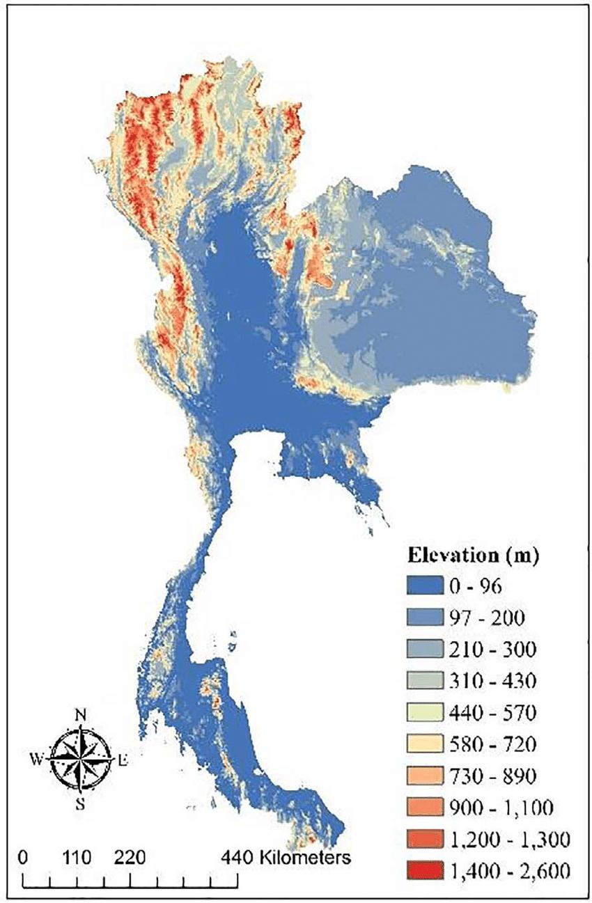
The Thailand elevation map shows the different altitudes of Thailand. This altitude map of Thailand will allow you to know where are the highest and lowest regions of Thailand in South-Eastern Asia. The Thailand elevation map is downloadable in PDF, printable and free.
Extreme points in Thailand are as follow as you can see in Thailand elevation map: Northernmost point: Myanmar border, Mae Sai District, Chiang Rai Province, at 20°28′N 99°57′E / 20.467°N 99.95°E. Southernmost point: Malaysian border, Betong District, Yala Province, at 5°37′N 101°8′E / 5.617°N 101.133°E. Easternmost point: Laos border, Khong Chiam District, Ubon Ratchathani Province, at 15°38′N 105°38′E / 15.633°N 105.633°E. Westernmost point: Myanmar border, Mae Sariang District, Mae Hong Son Province, at 18°34′N 97°21′E / 18.567°N 97.35°E. Elevation extremes in Thailand are: the highest elevation point is Doi Inthanon, 2,565 metres (8,415 ft), at 18°35′32″N 98°29′12″E / 18.59222°N 98.48667°E. The lowest elevation point is the Gulf of Thailand, 0 metres - sea level.
The GPS coordinates denote that Thailand is positioned to the north of the equator. In average, the land in Thailand is at an elevation of about 942 feet above sea level as its shown in Thailand elevation map. At its highest point, Thailand reaches a soaring altitude of 8,415 feet above sea level. Located in one of Thailand most famous districts, the Chom Thong District, the highest point is atop the Doi Inthanon Mountain. Thailand is at sea level with the Gulf of Thailand, meaning the lowest point of elevation is 0 feet above sea level.
Doi Inthanon (Thai: ดอยอินทนนท์(Pronunciation)) is the highest mountain in Thailand. It is located in Mae Chaem District, Chiang Mai Province as its mentioned in Thailand elevation map. This mountain is an ultra prominent peak and was also known in the past as Doi Luang (meaning big mountain) or Doi Ang Ka, meaning the crow pond top. Near the mountain base was a pond where many crows gathered. Doi Inthanon is part of the Thanon Thong Chai Range, a mountain range of the Thai highlands stretching southwards from the Daen Lao Range. This range, the southwesternmost of the Shan Highland system, separates the Salween watershed from the Mekong watershed. Other high peaks of the Loi Lar Mountain Range are Doi Luang Chiang Dao (2,175 m), Doi Pui (1,685 m), and Doi Suthep (1,601 m). In 1954, the forests around Doi Inthanon were preserved, creating Doi Inthanon National Park, as one of the original 14 National parks of Thailand.

The rivers in Thailand map shows the principal rivers with their names of Thailand. The rivers map of Thailand will allow you to find the main rivers which flow in and through Thailand in South-Eastern Asia. The Thailand rivers map is downloadable in PDF, printable and free.
The two principal river systems of Thailand are the Chao Phraya and the Mekong as you can see in Thailand rivers map. Together, these rivers support the irrigation for Thailand agricultural economy. In addition to these two large systems, there are a number of other river systems and individual rivers which drain the lands within Thailand borders into the Gulf of Thailand and the Andaman Sea. The Mekong is the only river system in Thailand which drains into the South China Sea. The Chao Phraya River System is the main river system of Thailand, as its basin defines much of the region of central Thailand. The Chao Phraya River begins at the confluence of the Ping and Nan river at Nakhon Sawan (also called Pak Nam Pho) in the Nakhon Sawan province. It then flows from north to south for 372 km from the central plains through Bangkok to the Gulf of Thailand. In Chainat, the river splits into the main river course and the Tha Chin river, which then flows parallel to the main river and exits to Gulf of Thailand at about 35 km west of Bangkok in Samut Sakhon. In the low alluvial plain which begins below the Chainat dam, many small canals (khlong) split off from the main river. The khlong are used for the irrigation of the region rice paddies.
There are numerous rivers which flow into the Gulf of Thailand, including a number of west coast gulf rivers, east coast gulf rivers, and rivers which drain into the gulf on the east coast of the Malay Peninsula as its shown in Thailand rivers map. The following river systems, in addition to the Chao Phraya, are the most significant gulf systems in Thailand: The Bang Pakong River is a river in eastern Thailand. The river originates at the confluence of the Nakhon Nayok River and the Prachinburi River at Pak Nam Yotaka in Amphoe Ban Sang, Prachinburi Province. The Phetchaburi River is a river in western Thailand. It originates in Kaeng Krachan National Park, Kaeng Krachan district and flows through Tha Yang, Ban Lat, Mueang Phetchaburi and mouths into the Bay of Bangkok in Ban Laem district. The Mae Klong River is a river in western Thailand. The Pran Buri River is a river in the Prachuap Khiri Khan Province, Thailand, on the Kra Isthmus of the Malay Peninsula. The Khlong Kui River drains into the Gulf of Thailand from the Malay Peninsula in Thailand. It flows through Ban Pong Kasang and Ban Thung Faek, Kui Buri district, Prachuap Khiri Khan Province. The Tapi River with its main tributary Phum Duang drain the area of Surat Thani Province. The total watershed of the river system is about 11,500 km². The Pattani River is the longest of all Thai rivers on the Malay Peninsula with a total length of 214 km.
The Mekong River, one of the world major rivers, drains into the South China Sea. It is the 11th-longest river in the world, and the 12th-largest by volume (discharging 475 km³ of water annually). Its estimated length is 4880 km, and it drains an area of 810,000 km² as its mentioned in Thailand rivers map. From the Tibetan Plateau it runs through China Yunnan province, Myanmar, Thailand, Laos, Cambodia and Vietnam. All except China and Myanmar belong to the Mekong River Commission. The extreme seasonal variations in flow and the presence of rapids and waterfalls have made navigation extremely difficult. Approximately half the river length is in China, where it is known as the Meigong in Chinese (Chinese: 湄公河; pinyin: Méigōng Hé). The river next forms the border between Myanmar and Laos for 200 km, at the end of which it meets the tributary Ruak River at the Golden Triangle. The Salawin River rises in Tibet (Tibetan [རྒྱལ་མོ་རྔུལ་ཆུ།]http://tibetanecology.org/Seven_River_Map.htm) after which it flows through Yunnan, where it is known as the Nujiang river (Chinese: 怒江; pinyin: Nù Jiāng), although either name can be used for the whole river. The river is 2815 km long. It then leaves China and meanders through Myanmar (where it is known as the Thanlwin) and Thailand (where it is known as the Salawin, Thai: สาละวิน) on its way to emptying in the Andaman Sea by Mawlamyaing (Moulmien).

The mountains in Thailand map shows the principal mountains with their names in Thailand. The mountains map of Thailand will allow you to find the main mountains ranges and highest mountains of Thailand in South-Eastern Asia. The Thailand mountains map is downloadable in PDF, printable and free.
The generally rolling countryside of the southeast Thailand has high hills in the centre and along the eastern boundary with Cambodia. Notable peaks are Mount Khieo, which rises to 2,614 feet (797 metres), and Mount Soi Dao, which attains a height of 5,471 feet (1,668 metres) as you can see in Thailand mountains map. The hills, reaching nearly to the sea, create a markedly indented coastline fringed with many islands. The southwestern portion of the country consists of a peninsula with a mountainous spine and a gently sloping sandy coastline. Higher mountains reaching about 4,900 feet (1,500 metres) line the peninsula on the west and contain narrow passes linking Thailand and Myanmar.
The northern mountainsof Thailand, the southeastern continuation of the uplift process that formed the Himalayas, extend southward along the Thai-Myanmar border and reach as far south as northern Malaysia. Long granitic ridges were formed when great masses of molten rock forced their way upward through the older sedimentary strata. Peaks average about 5,200 feet (l,600 metres) above sea level as its shown in Thailand mountains map. Mount Inthanon, at 8,481 feet (2,585 metres) the highest in the country, is in northwestern Thailand, near the historical city of Chiang Mai. The city is overshadowed by Mount Suthep, site of a famous Buddhist shrine and the royal summer palace. Some of the rugged limestone hills contain caves from which remains of prehistoric humans have been excavated.
If you hike one mountain in Thailand, let it be Doi Inthanon. Located around two hours from Chiang Mai, this is the country highest mountain, rising 2,565 metres above sea level and famous for its ultra-prominent summit. Towering 1,964 metres above sea level, Khao Mokoju (or Khao Mo Ko Chu) is the highest mountain in Mae Wong National Park as its mentioned in Thailand mountains map. Getting there and back again requires a five-day-long trek. The namesake of Phu Lang Ka National Park, Phu Lang Ka is 1,720 metres high. From the mountain, you can enjoy a wonderful view that takes in a rural valley, limestone outcrops and forests. Climbing Doi Chiang Dao, also referred to as Doi Luang Chiang Dao near Chiang Mai is sometimes considered to be the greatest one-day hike in northern Thailand. The third-tallest mountain in the country, this mountain is reached on a challenging uphill hike.

The Thailand climate map shows average temperature and climate zones of Thailand. This climate map of Thailand will allow you to know weather, average precipitation, average sunshine and different climates of Thailand in South-Eastern Asia. The Thailand climate map is downloadable in PDF, printable and free.
Most of Thailand has a Tropical wet and dry or savanna climate (Aw) according to the Köppen climate classification, while the South and the eastern tip of the East have a tropical monsoon climate (Am); countrywide, temperatures normally range from an average annual high of 38 °C (100.4 °F) to a low of 19 °C (66.2 °F) as you can see in Thailand climate map. During the dry season, the temperature rises dramatically in the second half of March, spiking to well over 40 °C (104 °F) in some areas by mid April when the Sun passes the Zenith. Southwest monsoons that arrive between May and July (except in the South) signal the advent of the rainy season (ruedu fon), which lasts into October and the cloud covering reduces the temperature again but the high humidity is experienced as 'hot and sticky'. November and December mark the onset of the dry season and night temperatures on high ground can occasionally drop to a light frost.
Temperatures begin to climb in January, and a hot sun parches the landscape. The dry season is shortest in the South because of the proximity of the sea to all parts of the Malay Peninsula as its shown in Thailand climate map. With only minor exceptions, every area of the country receives adequate rainfall, but the duration of the rainy season and the amount of rain vary substantially from region to region and with altitude. The Northeast experiences a long dry season although the dry 2007/2008 season lasted only from late November through mid March. Its red,(laterite) dense clayey soils retain water well, which limits their agricultural potential for many crops but is ideal for keeping the water in the paddy fields and local village reservoirs. The well drained, loose sandy alluvium of the Mekong flood plain is very fertile, the main crops being tomatoes on an industrial scale, tobacco, and pineapples.
Cyclones coming from the Pacific Ocean, known as typhoons, follow a trajectory from east to west: when they pass to the north, they affect the continental part of Thailand after releasing the bulk of energy over Vietnam, Laos and Cambodia, however, they can still bring heavy rains. When they follow a more southern trajectory, they can affect more directly the peninsular part of Thailand. They generally affect Thailand from June to December, although they are more frequent from September to November.The climate of Thailand is affected by the cycle, called ENSO, that includes the periods of El Niño and La Niña. In particular, during El Niño years, the December-February period is drier than normal in the part of Peninsular Thailand exposed to the rains (the eastern one), while the rest of the country, which in this period is normally dry, becomes hotter than normal as its mentioned in Thailand climate map.